We Provide cutting-edge tools LIDAR systems, and offer comprehensive training programs to ensure effective use of these technologies. Our goal is to empower local researchers, communities, and enthusiasts to unlock the secrets of the ocean with confidence and expertise.
What is LIDAR?
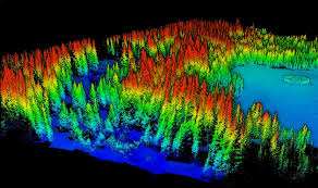
LIDAR, which stands for Light Detection and Ranging, is a technology used to map and study the surface of the Earth, including the ocean floor. It works by sending out laser pulses from an aircraft or drone. These pulses bounce off the surface and return to the LIDAR equipment. By measuring the time it takes for the laser pulses to return, we can create detailed and accurate maps of the landscape.
In simple terms, LIDAR is like using a flashlight to “see” in the dark. Imagine shining a flashlight at an object and measuring how long it takes for the light to bounce back to you. LIDAR does something similar but with laser beams, allowing us to create precise images of the ground and underwater features.
Ocean Data Pty Ltd is committed to sustainable and responsible exploration. Our technologies and training programs promote the careful study of marine environments, ensuring the preservation of our oceans while uncovering their many wonders. Through our efforts, we aim to foster a new generation of ocean explorers equipped to contribute to global marine knowledge and conservation.